A recently viral post on X (formerly Twitter) has unveiled unprecedented images and insights into the NASA-ISRO NISAR satellite. This collaboration between NASA and ISRO aims to provide critical earth observation data, and the revealed visuals highlight the satellite’s sophisticated design and operational readiness.
Viral images reveal detailed insights of NASA-ISRO’s NISAR satellite, a joint mission enhancing earth observation with advanced radar technology.
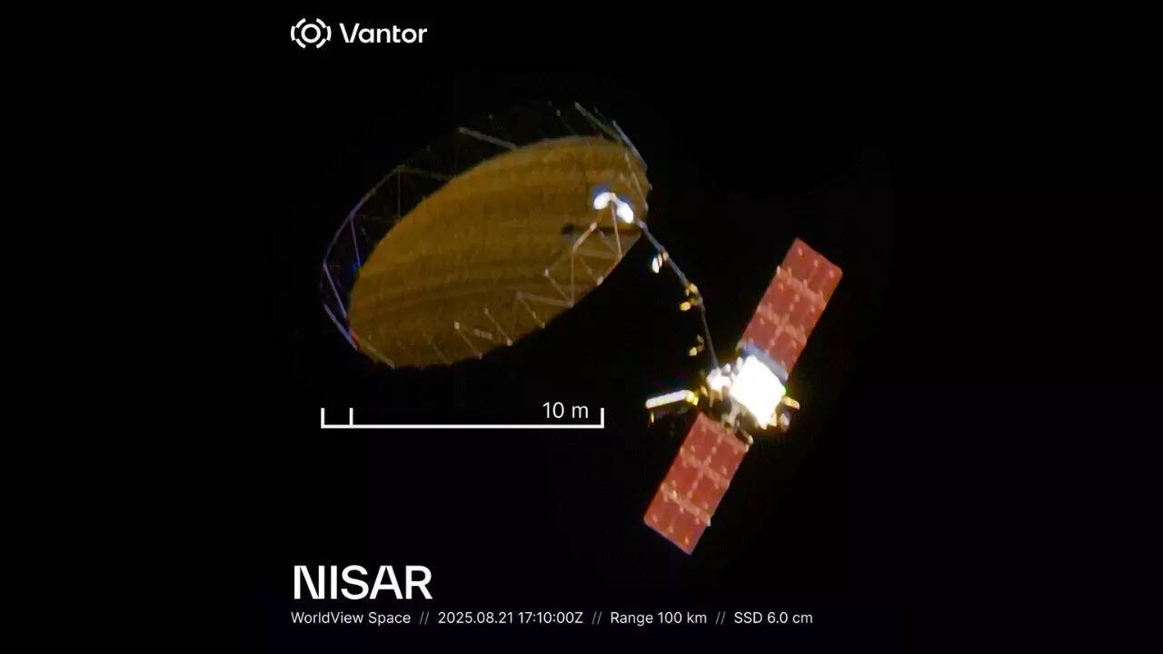
In a striking revelation, a viral post on X has showcased unprecedented details of the NASA-ISRO Synthetic Aperture Radar (NISAR) satellite, capturing widespread attention across the global scientific community. This joint mission, a collaboration between the United States’ NASA and India’s ISRO (Indian Space Research Organisation), promises to enhance earth observation capabilities beginning from its scheduled launch in 2025.
The NISAR satellite is designed to monitor and measure changes in Earth’s surface, including ecosystems, natural hazards, and climate phenomena, using advanced radar imaging technology. The viral images provide a detailed glimpse into the satellite’s intricate instrumentation and robust structural design, which until now had remained largely unseen by the public.
According to official statements, NISAR features a dual-frequency L-band and S-band synthetic aperture radar capable of producing high-resolution, all-weather imagery of the planet. This capability will enable scientists to study the dynamics of land deformation, ice sheet movement, and vegetation structure with unprecedented precision.
The collaboration stems from NASA’s and ISRO’s shared objective to leverage space technology in addressing climate change and natural disaster risks worldwide. Scheduled to be launched aboard a SpaceX Falcon 9 rocket, NISAR’s deployment promises a significant advancement in satellite-based earth observations.
“The unveiling of these visuals marks an important milestone in the NASA-ISRO partnership,” said Dr. Priya Natarajan, a space systems expert unaffiliated with the project. “The images not only display the satellite’s technological sophistication but also underscore the global cooperation driving us toward better understanding our planet.”
The viral social media post has sparked renewed public interest in space science and international cooperation in space technology. Experts highlight that the data acquired by NISAR will be vital for researchers, policymakers, and disaster management agencies.
In summary, the NASA-ISRO NISAR satellite represents a significant leap forward in earth observation technology. The recent viral images on X serve to illuminate the satellite’s advanced capabilities and reinforce the importance of global collaborations in space exploration. As the launch date approaches, scientists worldwide eagerly anticipate the valuable data that NISAR will provide to better understand and protect our planet.